
Divisadero Round Trip
Now that we have explained how to get to Lake Valle de Bravo during your paragliding trip in Mexico, it is time to try a round trip. It's always rewarding to come back to where you started, after a few hours of flight.
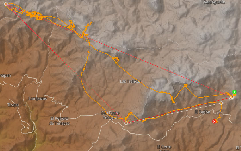
The cross route that we suggest consists of going to the western end of the massif, then considering the return. We therefore start from the same take-off, refuel at altitude before passing to the Peñon, then we leave for La Pared, the G-Spot, before joining the Maguey.
These steps are detailed in the previous articles:
Arrived at Maguey, instead of going towards Cerro Gordo, continue west. It will therefore be necessary to go beyond the “tres reyes” three characteristic mineral teeth, supposed to represent the three wise men. Be careful not to go too low in the pass, because there is a fairly marked venturi at this level, and you could end up descending on the spot ...
Another remark, here the breeze generally blows in the South-West, if you plan to approach the "tres reyes" to recover, you will have to do it on this side, otherwise you will find yourself downwind ...
In short, before passing the tres reyes, and continuing west, it's worth the wait to gain altitude.
Les Tres Reyes and in the distance, the Divisadero.
To continue west, you have two options:
The options
- take advantage of the thermodynamics of the plateau cliff. This only applies if you are at the minimum altitude of the plateau. If you lose altitude it is better to go to the plain without delay to always find yourself in the finesse of a cow. If you find yourself to the west of Tres Reyes, we can consider going back to this side.
- take advantage of the convergence that is on the board. Obviously, if it is marked by clouds, it is easier. And that implies that you have gained altitude. Here you will find yourself higher in absolute altitude (relative to sea level), but the plateau is also quite high. It's up to you ... I think you need to know a little about the site to venture onto the plateau with 400 or 500 meters of relative altitude.
But it is sometimes the right option which allows you to stay above the inversion, fully on the accelerator bar in + 4m / s for several kilometers kilometers sometimes, while other paragliders are much lower , stuck in the inversion at the cliff.
Before reaching the Divisadero, there are still some turbulent areas that I prefer to pass with altitude. It's hard to describe them to you here, but be aware that it's not seagull crest all the way.
Arrived at the Divisadero, we can add a few kilometers by taking a thermal over the rocky teeth at its end, and push a little further west, before turning around.
The return can be done either by the cliff of the plateau, or above the plateau (Cf the options). To return to the starting point, and land at the Piano (the official landing), several choices are available to you from the Maguey.
- Go through the mesa (the plateau that you had left and flown over from the G-Spot). In general we recover well on the vertical cliffs facing west. This is all the more true when they return home, they begin to be exposed to the sun.
- Push up to Espinazo (southern point of the mesa, south of G-Spot). This tip acts as a heat collector. It's a little further but in general it works. Remember to ensure the full altitude in Espinazo, because then to return to the Peñon, you can find yourself downwind, if you start too low.
Variants
- Instead of going back and forth, you can make a triangle.
At the Divisadero, head south, towards La Pila. Here we find ourselves facing the wind, in a plain area. In short, it is less obvious. Go with others to optimize your chances. The "Pila" is a mine, it is well recognized with its excavation area and its artificial lake. The return will be via the Tres Reyes, or Espinazo. - When you get to La Pila, you can even go further south, going towards "Aguila". It will be necessary to gain altitude at La Pila. Personally I do it often, but I'm not sure I want to bring people there. We are low, in a deep valley, with few cows. But it makes a nice triangle.
In addition, we cross a gorge (canyon), difficult to pass on foot. In short, the return will be complicated, and may cost you time and money.
The cracks go even further to complete an FAI triangle of more than 100 kilometers. - If you go through Maguey or directly reach Cerro Gordo, thanks to a confluence, we can obviously consider the return to the lake of Valle de Bravo.
Useful links
Guide to Valle de Bravo (in English).