
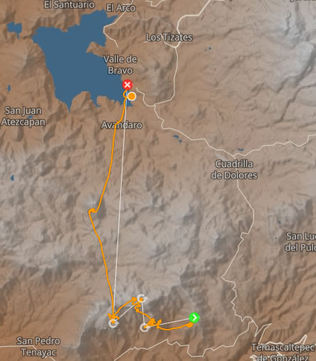
Cross paragliding:
Valle de Bravo by Cerro Gordo
This route towards Valle is reserved for more seasoned pilots: The thermals are frankly stronger around the pared (the wall, located between the G-Spot and the Peñon), the longer transitions, and the cows rarer. You have been warned.
The locations of the thermal currents around the Peñon, the wall and the G point are variable, the transitions are a bit longer and with fewer landings.
I advise you to open the map of "beacons", present in the page cross country, so that you can refer to it. The waypoints will be: the G-spot, Espinazo, Maguey and Cerro Gordo.
After having taken at least 2,500 m (i.e. 300 meters above take-off), you transit towards the Peñon. Take care to make the ceiling, the higher you get to the Peñon, the more likely you are to find an organized thermal.
Be careful when traveling not to stick too much to the relief, especially on the first part (East of the Peñon) which is downwind of the breeze.
Here, we find a powerful thermal, but I advise against it. In short, making a dog leash to get to the windward part is still the best option (unless you have the knife between your teeth).
Note that even in the wind, the thermals in relief are often powerful, and when this is the case, this means that it rises just as well in the wind and away from the Peñon. It is then better organized, and we are far from the relief. Obviously, it will be necessary to ensure that the priorities are respected, in the direction of rotation imposed (local rule), and to stay on the fineness of the landing, because there are relatively few viable emergency landings.
If you get to the top of the Peñon, keep climbing as much as possible: the higher you are, the more options you have. Make sure that the drift does not take you downwind of the Peñon, in any case not too fast or too low. We can then consider going to the pared (the wall).
The higher we get, the more organized the thermals will be. If the day is very good and you climb the wall enough, you don't need to go to point G, but this is usually where the thermals go highest, so it is okay to use them for the next transition. If it's a great day, we can even skip the pared, and go straight to the G-Spot.
At the G-Spot, like a braid, the thermals converge: Those of the cliffs, upwind and downwind, as well as that of the plateau. It is therefore often strong.
From this point, for simplicity, there are three possible routes:
1- Return to the Sacamecate
You can go to Sacamecate Where San Agustín and take the simple path that I explained on the page Valle de Bravo by Peñitas, this transition makes you fly over the Mesa and if you are not very high you must find a thermal before Sacamecate or San Agustín. If you can't find anything you will eventually land on the Mesa and have to walk unless you find a car on the return.
2- Cerro Gordo live
The second route is to go directly to Cerro Gordo. Go as high as possible, let yourself be carried by the air mass (if it is carrying), open your eyes, in search of zopilotes (local raptors), developing clouds ... because there are few thermal sources evident during the transition. In Cerro Gordo, the thermals converge, but the point of convergence changes from day to day. In short, it doesn't work every time, unless you get to the top, and have time to prospect. You wouldn't be the first to land there, believe me! Prefer the north side (lake side), which at least allows you to take a taxi on the road, without having to walk too much.
3- Cerro Gordo via Maguey
The last route is from point G if you can't climb so much is to fly towards Maguey. Powerful thermals converge at Maguey, and there is a venturi. Do not wait until you are too low to reach a relief ground. Wait to wait 3200 m before transiting towards Cerro Gordo. Going lower is much more random.
For routes 2 and 3, assuming you get to Cerro Gordo, if you can climb up to an elevation of 3,200 meters, the lake is usually within reach.