
You might be looking for this page.
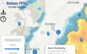
This paragliding map will allow you to get real-time data collected from the FFVL (french paragliding organization) weather radar network.
In addition, you can gain access to the pioupiou network (green pinpoints), real-time rain, airspaces, thermals, flying sites (red pinpoints)… you name it.
Also have a look at this blog post to have an intro about how it works.
Enjoy, it's actually the most popular page from this website, even more than the homepage itself!
Please make sure you Facebook-like the page, if it is helpful to you!