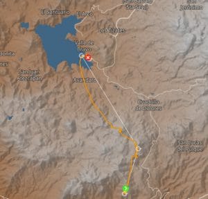
The XC flight from Peñon to Valle has two basic routes. the road to Peñitas is the easiest route to stay in the finesse of the main road. On this route you can just take a taxi without having to walk much, as it is a major traffic axis between Temascaltepec and Valle de Bravo. It is also a recommended route for students who are starting to fly XC as there are several possible landings.
During the cross-country season (November - February) it is recommended not to take off after 1 p.m. on the morning flight. Thermal cycles at take-off generally develop from 10 a.m. to strong cycles at 1 p.m. The felt wind also increases significantly in the afternoon when the breeze sets in.
Choose your cycles wisely. Depending on the conditions and the time of day, you will have to take off during the passage of thermal, or, on the contrary, out of cycle.
From takeoff, it is more important here than elsewhere to be well focused on your flight, because the thermals can be strong. We stay on course, we have plenty of time to get into the harness… without letting go of the controls! This is not a soaring site, it is not advisable to “scratch” near the relief.
The “service thermal” is in the “bowl” to the left of takeoff, but it also triggers very well on the “Chichi” (rocky outgrowth, facing takeoff). You have to climb at least 400m above take-off (or less with a high-performance paraglider) to reach the second valley behind. Looking northeast behind take off, you can see two rocks (Peñitas) on your left side and a hill right in front of you (known as Tres Cruces Hill - “the three crosses”). This valley does not generally work well, especially in the morning, and in addition you may end up downwind. It is recommended that you do not jump behind take-off before noon during the XC season.
The best strategy is to get as high as possible to get above the usually working Peñitas and fly directly towards them, if you get below you can try to surf the second Peñita but it is quite difficult to 'hope to go back to this stage; If you don't have a lot of height to cross the Peñitas, I recommend trying to hook up the thermal that usually leaves the hill of the three crosses. Otherwise, a little further on, there is a field with horseshoe-shaped stables, which generally produce a saving thermal. The last resort is a thermal at the end of the last field but it's not very consistent and if you drift too far downwind you may miss landings.
If you manage to climb in any of these three options, the next step is to climb Sacamecate. It usually works on the windward side, which is usually the southwest side (where there is a small hut) or on the northeast side and heading towards the landfill. If you do not climb well and you have the fields towards the Jovan in finesse, you can fly over the landfill ("basurero"), which can be recognized by the smell. If it stinks, it's because it's going up! If you manage to climb well in one of these thermals, it is common to climb more than take off and end up in the confluence.
If you are climbing Sacamecate I recommend taking the maximum possible height for the next transition to Cerro del San Agustín. If you prefer to stay within reach of the landings and the main road you can go to Jovan but this valley is difficult as it does not have constant thermal currents and from there to Valle you have a headwind. From Jovan if you want to go to Valle make sure you go to the fields of Casas Viejas and try to get there to reach Valle.
If you go through San Agustín, the confluence and thermal springs tend to change a lot depending on the wind intensity and wind direction from day to day. For this reason, it is advisable to take a lot of height to find the lift without having to enter the Mesa (the plateau). Confluence works best higher up, so coming up with more height can be very helpful. Learn how to use clouds - if there are any - to infer the location of the confluence.
If you're willing to risk a long walk, you can look for thermals on the Mesa south of San Agustín, where there are several landings. The residents were sometimes unwelcoming there, but it is also sometimes known that they drove pilots for several kilometers to the main road. Bring change, just in case.
If you manage to climb to San Agustín and have 1000m of gain (over 3000m AMSL), you can normally slide to Valle. Be careful, however, the possible cows are becoming scarce due to urbanization, and the lower you get, the more you will be countered because under the influence of the lake breeze.
A good benchmark for height is the take-off from the Torre (that of the lake). If you think you will arrive lower, before entering the venturi, it is better to give up.

