Last update : 11/02/2022
Knowing the weather readings in real time is much better than the forecast.
The FFVL offers a very useful tool, and I took advantage of the last days of troubled weather to offer a “2.0” version. By also adding the rain radar, and some "goodies" ...
FFVL weather beacons
Table of contents
Historically, a weather beacon is an anemometer, coupled to a good old Nokia 3210 phone, for example, equipped with a SIM card, powered by an auxiliary battery (or a solar sensor).
Since the weather beacons have existed, they have been accessible on our VHF radios on the FFVL frequency (143.9875 Mhz). An automaton reports these readings every 15 or 20 minutes: name of the site, orientation, average wind, gusts. Who says radio, says "range". And even if when flying in Corsica (even towards Ajaccio), we sometimes manage - in flight - to capture those of the continent, this range is often limited by the relief ...
If we were out of range, or in a hurry, it was possible to obtain this information by calling a voice server on 0825 150 289 (18 euro cents / minute + price of the call). I speak in the past tense, but this service still exists!
Then the Internet came along.
In 2005, the FFVL made a website available to its practitioners, listing all the “official” beacons of free flight sites. It is balisemeteo.com. The site is a bit dated, as you can tell from its design, but it has the merit of existing, and I'm sure it is viewed by hundreds, if not thousands, of paragliders every day.
Then, adapting to the times, the federation released a mobile version of the site, based on jQuery mobile (2010) accessible via https://m.ffvl.fr/.
Personally, when I consult balisemeteo from my smartphone, and someone suggests that I switch to the mobile version, I prefer to stay on the “desktop” version, because I find the ergonomics of the “mobile” version a little degraded. Question of perspective !
Condorito FFVL beacons
A good keyword?
By consulting the statistics of my website, I see that at least two users have come across my site by typing on Google "FFVL tag".
It's funny because in fact my site doesn't talk about it (so far)!
I am proposing the "take-off beacon" from Valle de Bravo, in Mexico. And I'm probably talking a bit about the “FFVL”. Google had to mix it up.
Let's take the opportunity to capitalize on this information! It may help boost my SEO, it won't hurt him ...
The project
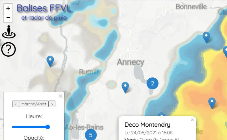
I offer you an interactive map (Google Maps style), presenting the FFVL beacons, with their respective data.
At the end of 2020, the FFVL publishes a item, in which it offers its data in OpenData.
The federation provides this data in order to:
disseminate as widely as possible reference information contributing to the safety of our practices;
encourage the development of innovative applications meeting the needs of its licensees.
In fact, there is a "cartographic" version of the beacons also offered by the FFVL but it's quite anecdotal. So much so that I had forgotten that this project existed. I rediscovered it when I had already started my development.
So I tried to propose a new “app” which brings a real improvement compared to the existing one:
Data recovery
In the FFVL beacon map, markers are placed according to the GPS coordinates of the beacon, with a link to the beacon page (balisemeteo.com?id=xx). Now the data is directly displayed in the map.
Geolocation
 This makes it possible to offer the beacons near me: an increasingly popular feature since the advent of smartphones. The map centers (and zooms in) on your location. Just click on the corresponding icon. For obvious security and privacy reasons, you may need to allow / unblock this feature to benefit from it.
Rain radar
 As long as you have the weather beacons in real time, you might as well have the precipitation! Particularly useful when the weather is uncertain. It allows you to avoid a curtain of rain, in any case to make your decision (to steal or to give up) knowingly.
I use the data from rainviewer.com. Thanks to them. All you have to do is click on the corresponding icon (bottom left of the map).
Custom url
Rather than having to click, move and zoom on the map for each new visit, the geolocation parameters (zoom, latitude and longitude) are updated in the url with each interaction. It is therefore possible to bookmark your favorite tag, share it with friends.
So, if you live on Reunion Island, here is the link.
If you want to integrate it on your club's site, here you just have to copy and paste the following code (by adapting the parameters):
<iframe src="https://parapente-mexico.com/balise-ffvl/?ttl=Rh%C3%B4ne-Alpes#8/45.300/3.194" width="100%" height="600"></iframe>Bonus: Map of thermals and skyways
By clicking on the top right of the map, you can change the “base map”, but also display the thermals, as well as the “skyways” (aggregation of the most popular cross-country routes). Thanks to Michi von Känel for allowing me to use the sound data excellent site ! A wealth of information to prepare your travel with his paraglider.
And this is what it looks like:
Application evolution
This project was born out of a project lasting a few days, but since we have a very rotten season, I am adding features over time:
Addition of airspaces
On 07/15/2021, I added the airspaces (from OpenAIP.net). It is practical to respect the air regulations in paragliding, and to prepare its flights of distance. Click on the icon at the top right to access it.
Research
You want to search for a weather beacon whose name you know, to access it more quickly?
Click on the small magnifying glass, and use the search box provided.
FFVL sites (paragliding and hang-gliding)
On 07/31/2021, another beautiful rainy weekend, and as luck would have it, I'm on vacation!
So I added the paragliding sites on the map (take off / landing). Click on the icon at the top right to access it.
Other existing applications
Pioupious / OpenWindMap
In addition to the official guidelines of the FFVL, Nicolas Baldeck, already creator of meteo-paragliding.com, proposes in 2015 an anemometer giving the wind in real time, "anywhere, even where there is neither electricity nor internet". No need for a SIM card or wifi, it uses the sigfox network, to transmit the data. Everyone can now plant a "pioupiou", where they hear it, and even move it according to their desires (or the seasons), the GPS coordinates of the beacon also being transmitted, and listed on a map. Convenient for those who are far from any weather station. By accessing wind data from home, specifically at your own flight site, this can for example prevent unnecessary travel if the wind is too strong or out of focus, or beyond your own skills. A revolution !
After some setbacks with unscrupulous partners, the project collapsed. But at the end of 2020, he launched the OpenWindMap community, to give a second life to this project.
I may integrate the pioupious data on the map. To be continued.
It is done ! (Data from Pioupious can now be accessed as an option via the “layers” menu at the top right). This is also what fire was already doing mobibalises a few years ago (display FFVL + Pioupiou data).
SpotAir
Pedro, the author of mobibalises, launched in 2017, Spotair.
The SpotAir project is still maintained, and even continues to grow in 2021. It lists the FFVL beacons, the pioupious, as well as those of the romma network (alpine mountain weather observation network), but also beacons abroad, a network of webcams, airspace, snow level, a mini-social network (to share tips “where it flies”). ... In short, it's heavy!
winds.mobi
Fairly complete, it is closer to SpotAir, which I prefer.
https://winds.mobi/
Conclusion
The idea was to take care of myself intelligently for 3-4 rainy days.
Aggregate the data in one place, and incidentally improve my SEO.
If it can be of use to other paragliders, I will be delighted. In any case me, it serves me well!
Now, if we look for “rain ffvl tag”On Google, we come across the page in question.
Ah! I forgot the main thing, the address of the page:
Feel free to tell me what you think about it, and use it! You can contact me via the footer form, to suggest an improvement, or report a bug.
PS: In the same vein, I also propose you the directory of paragliding schools.