Last update : 10/09/2021
How do I determine the correct height for the final approach?
How do you know if you will succeed in passing a ridge or an obstacle?
These are the recurring questions of most progressive paraglider pilots.
Managing the height in paragliding
Table of contents
Paragliding is indeed one of the rare activities where you have to manage an additional dimension: height.
In addition, we have no engine, so when we are too short, impossible to go around, and if we are too long, the flight may end in the background. In short, it is an essential concept, but rarely explained in training. At best, you have to repeat the landings.
And as soon as we change site, the configuration of the place changes (dimensions, possible slope, force of the wind, obstacles, turbulence, venturi), our achievements are therefore called into question.
Some pilots unconsciously manage to assess the situation, without being able to explain it. Others struggle their whole lives. There is, however, a simple method, which this article attempts to explain.
Explanations
When we zoom in on Google Maps (or Google Earth), all the points move away (start on the sides in a concentric way) except one which remains fixed: This is what I call the stationary point. If you fell from a plane, the same would happen. The remaining fixed point would be where you would end your free fall. Fortunately, normally we take a parachute!
If it wasn't clear, here is the map of weather beacons in real time (+ rain + pioupious !!), here centered on that of Montmin (Takeoff from La Forclaz), then click several times on the "+" button (top left) to zoom
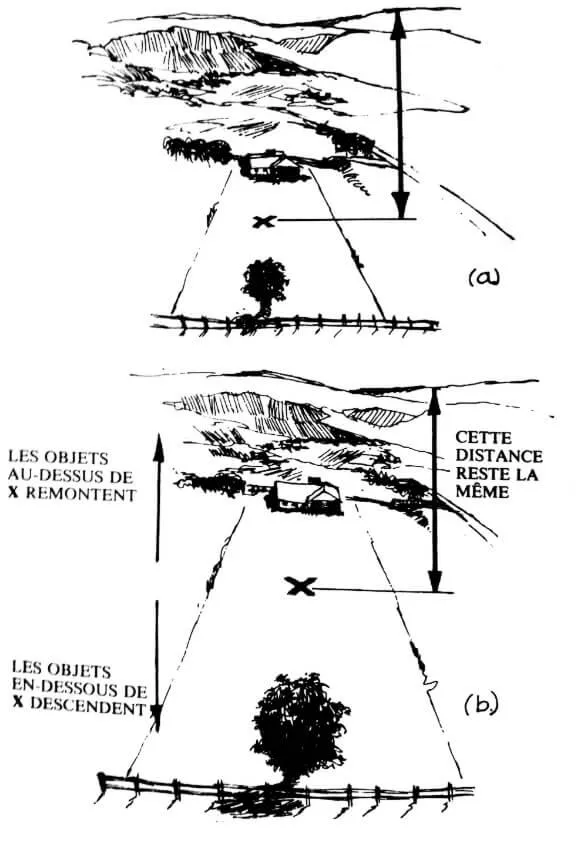
The same thing happens in flight, even if we do not arrive vertically on a given point, but according to a descent path corresponding to our glide angle, possibly modified by the direction of the wind, and the movements of the air mass.
In the drawing above, we have in (A), the subjective view of an approaching pilot.
At the entrance to the land, a beautiful barrier, a tree in the middle, and at the bottom of the land, a house.
As the pilot gets closer (B), if all goes well, like here, the tree and barrier come down in my line of sight, as the house goes up. A single point remains fixed, here symbolized by an "X". This is the place where I will land, if the air conditions remain the same.
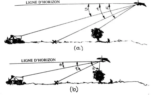
Now let's look at the same case, but in profile:
We have three "theoretical" glide angles.
- Angle S: horizontal - house in the back ground
- Angle T: horizontal - midfield
- Angle U: horizontal - tree entering the ground
In the first case (A), the pilot and still high, he assesses the situation before a possible entry into the final. It is still high enough to make a few more turns and consume its excess altitude.
In (B), the angle S becomes smaller (the house "rises" towards the horizon). So I will never go that far.
The angle U increases: The tree goes down in my field of vision, the pilot is sure to pass the obstacle.
The only angle that remains constant (angle T) is that of the end point (midfield). Phew! The pilot will pose in the field.
In view of these sketches, we can say that:
The point on the ground which appears stationary is the one towards which your trajectory tends.
Anything beyond this point on the ground seems to rise, so it will never ever be hit.
Any object located before the point on the ground seems to descend, so it will be passed.
Practical work
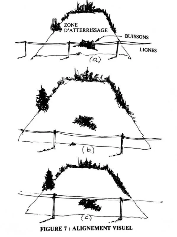
In the sketch above, we have in (A), the first "snapshot".
In (B), the pilot approaches the situation is ideal: one has the impression of zooming in on the photo. The entrance to the land, and its power lines, descend into my field of vision. The stationary point remains in the center of the field: it passes!
In (C), these power lines remain at the same level, or even rise in my field of vision: It's time to put in place a plan B, which of course you had thought about before! In paragliding, like in chess, you must always be one step ahead if you want to keep your hand and keep playing!
Concrete cases
As a tandem instructor based in Talloires (the great outdoors), we often take off from La Forclaz. To return to the landing, we must gain altitude, to be at a necessary and sufficient height allowing us to reach Talloires. This is all the more true as we have a component of headwind (more exactly the breeze, coming from Annecy), which tends to degrade our finesse. This breeze is all the more marked the lower you are.
In short, if when you leave the "rocher du roux", you can see the landing, but when you get closer, it disappears behind the Hermitage of Saint Germain, it means that you have better emergency landing) on the Verel plateau, rather than trying to force the passage, and end up in an urbanized area, with very limited possibilities to land.
TO Valle de Bravo in Mexico, the situation is similar, we often reach much higher than necessary when we reach the landing of the lake from the takeoff of El Peñon, because we fly over a wooded area, then urbanized, and finally the lake itself. So many places not really favorable to an improvised landing, especially as the breeze strengthens in low layer. I know pilots who ended up all wet, or in a tree, for lack of caution ...
It is better to cut short a flight by "being too careful", than to gamble with your life.
Refine your precision when landing a paraglider
In relatively laminar conditions *, you can try the following exercise:
You arrive at the landing on a long final (therefore facing the wind), with an intermediate flight regime (said to be of maximum finesse, hands on the shoulders).
Your end point mounted in your field of vision, it means that I will pose before. I mounted hands to try to bring me closer.
Your end point go down in your field of vision, it means that I will pose beyond (after). I come down so the hands - reasonably of course - to try to get closer to me (mini drop rate). Of course, I don't forget to raise my hands high enough to regain a reserve of speed, and therefore of energy, and thus fight against the wind gradient.
Thanks to these exercises, we can find a way to determine your maximum finesse speed against the wind (see Polar gears). While flying at a constant speed, locate the point in front of you which appears to be enlarging but remains stationary. Raise your hands and observe the reaction of the point in question: if it seems to be going down, or getting closer, it means that the glide angle is improving.
I often carry out this exercise with my students during a progression internship, and that I guide them to the landing of Doussard. This landing is breeze, often strong, but not very thermal, which allows to descend almost on the spot above its end point. If you fly by the sea, it is also a very favorable playground for this type of exercise.
At Mexico, the landing of Santa Maria is impressive because it is very cramped, (one or two tennis courts). Yet by applying the technique of stationary point, it is easy to land there, because it is also in breeze. Hereinafter Taylor's landing, after his first cross with me, in December 2020.
He was so happy that he left me a great review on Google, which I reproduce here:
Olivier and I shared a wonderful 3 hour XC adventure all around Valle de Bravo. We launched together at el Peñon and made quick work towards the walls. Before I knew it I was at cloudbase and we made the transition over to the "3 kings" and continued our journey down the divisadero ridge. We chatted on radio which took away some of my apprehension of being in unfamiliar terrain. As we made our way back from the end of the ridge towards the 3 kings I started having more trouble staying up (fighting a headwind, less lift, lower cloudbase etc.). I really had to fight to stay in the broken thermals. Although I had loss track of Olivier at this point, he had not lost track of me! He came on the radio with words of encouragement, "stick with it Taylor!" You got this! ". As I continued my turns in the thermal I could see Olivier above me showing me where the thermals were drifting. He continued to climb higher and higher showing me the invisible path of lift that would bring me back to the clouds. We continued to climb together (him always slightly infront showing me the way) as we let the thermals drift us deeper and deeper over the mesa. I pointed my glider towards Valle de Bravo and as I soared past cerro gordo I knew I was going to make it! Olivier at this point was around 1000 feet below me, as instead of heading straight for the safety of Valle, he waited around cerro gordo to make sure that I was going to be ok and that I would make it there. I came on radio excited that I was going to make it to the lake and apologized for making him wait around. He said, “don't worry about me, I will make it work” and he did. We both landed at the lake LZ in Valle de bravo having just flown more than 50 miles all around the surrounding mountains and valleys. Sufficiently stoked and mentally exhausted, we shared a beer and enjoyed the sun and the breeze. This was the best flight of my life and Olivier helped make it possible. 10/10 would do it again.
* I am talking about laminar conditions, because in thermal conditions, we will be careful to keep the wing at a reasonable incidence, the landing precision then becomes secondary.
Landing precision: a practice in itself
Rather reserved for parachuting, landing precision (PA) consists of landing on a target.
A time prohibited in France in paragliding (because too many accidents following stalls), the practice has been given back to the honor in recent years by the FFVL, because many international competitions (and even world championships) are organized by the FAI (Fédération Aéronautique Internationale). We should not stay on the sidelines! Sails are even developed specifically for this activity, such as the " Point "From" Da Vinci "!
More information on the FFVL website.
Other considerations
the pumping (or flapping): You will see some pilots perform this technique to refine their landing precision. It can be tempting to imitate them.
However, this is not necessarily a good idea. We drop our hands abruptly, before raising them up, several times in a row. We send contradictory information to his wing: Pick up! No it's a joke. Off hook ! No it's a joke ... Sometimes she takes your instructions at face value, and it ends badly. This can be done in very specific air conditions, and knowing the wing well, by experienced pilots. Avoid for most pilots!
If you have to pass a pass, or a ridge at low altitude, you may encounter descents, turbulence (because you are downwind). On the other hand, the wind often accelerates at this level (compression of the air flow, venturi). In short, take margins!
Hereinafter Chrigel Maurer, arguably the best rider in the world, when he arrived at Mont Gros (RedBull X-Alps 2013).
Pumping, starting off, using the accelerator close to the ground… Don't try this at home!
The technique of stationary point is mainly used with headwinds, because it is under these conditions that our finesse deteriorates considerably, and that we may have to ask questions about our chances of success: Will I pass this pass, reach landing?
But the good news is that this technique works perfectly whatever the direction of the wind !
Give back to Caesar what belongs to him
The illustrative sketches are from a book by Dennis Pagen, titled “Mastering Flight”.
I found this book and others by the same author in Valle de Bravo during my first stay.
It was even in French! Improbable but true!
Dennis Pagen has written a dozen books on free flight, and nearly 400 articles.
These books are a little dated, and mainly concern hang-gliding (at the time, paragliding did not exist), but the fundamentals remain the same today.
The best known of his works is called " Understanding the Sky". It is a bit the counterpart of " sky visitors". I highly recommend reading it, as long as you speak English, even though it dates back to the last century (1992)!